Our expedition, originally intended to be in Tibet, was compromised by the Chinese authorities who varied their entry criteria at the last minute. Our plan had been to cross Tibet from Lhasa to Kailas and Guge, then trek out via the Limi Valley in Nepal.
This trek has us arriving in the remote Humla region of Nepal by plane into Simikot, trekking up the Karnali River valley for four days to the Tibetan border at Hilsa, then trekking through the Limi Valley on our original schedule.
There is a 15 minute video of our trek on YouTube
Wednesday
6 June
Ahead
of the return of the rest of our team from Bhutan, we took a short sightseeing
trip to Patan, just across the Bagmati River, south of Kathmandu. I'd been
before, but the Durbar Square with its many Newari and Indian temples never
fails to impress, and the relatively new Patan Museum within the old palace
building was worth a look.
 |
| Kwa Bahal, the 'Golden Temple' |
 |
| Entrance mandala |
We
wandered the back streets, visited Kwa Bahal, the tiny Buddhist monastery known
as the Golden Temple, and spent some time with the purveyor of marvellously
crafted 'singing bowls' before heading back to the hotel. By lunchtime it was
oppressively hot in the city, so lunch was called for and we met up with the
rest of the gang mid afternoon.
 |
| Ommmmmm...... |
A
good dinner at the Garden of Dreams again, catching up on all the news, and a
couple of us stopped by to listen to some good live jazz at a bar near the
hotel. A nice way to complete the day!
Tomorrow
the team start their next adventure...trekking the Humla region in the
northwest of Nepal. I think we're all ready to leave the polluted air of
Kathmandu!
Thursday
7 June
A
lazy start, and eventually away to the domestic terminal and a one hour flight
to Nepalgunj. It was a hazy flight, punctuated by some towering cumulo-nimbus,
but we touched down on the flat plain surrounding the town after about one
hour, having passed over some low density forest and acres of parched land.
Here
we are just a few km from the Indian border, and the whole area feels more
Indian than Nepalese, with the usual appalling driving standards as we passed
through this scruffy and dusty border town on the way to our hotel. We
immediately renamed it 'Nepalgrunge.'
We
were obviously staying at the best hotel in town (!) which seemed to be be in
the process of extensive 'modernisation', but it did the job and gave some
respite from the searing heat outside - 39 degrees and about 80% humidity.
An
early dinner and to bed, hoping that the fan and a/c would keep going and keep
the local mozzies at bay.
Friday
8 June
An
uneventful night, several power cuts causing the fan and air con to stop
working at times, and a 0400 alarm call to get us up for the airport transfer
and flight to Simikot. Once again, we feel we're out in the boondocks, and all
looking forward to 'cooler' air up at Simikot, the start point of our trek,
which is at just under 3000m altitude. We got to the airport in a flash, helped
by the lack of traffic at this hour, but found that the plane to Simikot had
arrived but had been scheduled to do a run up to Dolpo and back, delaying our
flight until 0930. The team's heads were down a bit after this, with an
oppressively hot departure 'lounge', local TV blaring away, and 'helpful' observations
from a charity worker who had come down from Simikot this morning...he had
great delight in telling us how his colleague recently got delayed in Simikot
for NINE days due to weather.
Subsequently
checking with our guide, the nearest road head from Simikot is four days
trekking, and the only other option in weather that prevented fixed wing
flights would be an expensive helicopter ride! Needless to say, the team went a
bit quiet after that!
Our
plane eventually arrived back from Dolpo, a battered Twin Otter which they
happily filled with aviation fuel as we queued up to go up the steps. Luggage
was chucked on the front seats, some seatbelts didn't work, and more luggage
blocked the rear emergency exits. Hey ho...we're on an adventure again!
 |
| Hmmm, not sure about airline safety regs here! |
 |
| Arrival in Simikot |
 |
| The one that didn't make it! |
The
flight took 45 minutes, leaving the flat plains around Nepalgunj and quickly
into the terraced hill country to the north, and eventually crossing numerous
high mountain ridges intersected by deep river valleys. The final approach was
interesting, a fairly sharp turn and a heavy landing on the short Simikot (now
tarmac) runway.
 |
| Local Humla woman looking for porter work |
 |
| Quick lunch before the hard work starts! |
We
cleared the airport, an official extracting some spurious 'tax' for our group,
and we then had a quick lunch prepared by our new crew whilst the mules and
horses were loaded. We now have:
10
mules
2
horses
4
men to manage the animals
Our
chief Sherpa Kaji
Cook
Assistant
cook
Four
other chaps who do porter work and general camp duties.
Quite
a team!
Our
walk to the first camp started at about noon and we climbed steeply out of
Simikot, giving us fine views back to the village and the snow capped mountains
towering over it to the east. A good path, and we quickly gained 250m, noticing
that the folks in these parts are of a very different tribal background, the
women sporting nose rings and heavy gold earrings. Generally, people were
friendly on the trail, but the local kids were somewhat over-persistent in
their demand for sweets and pens. 'Hello, ben' was all we heard.
Our
initial ascent was followed by a steep 800m descent to the village of Masigaon,
tricky in places due to loose grit on the rocks and the steepness of the
ground. As we got lower, it got hotter and hotter, but our guide stopped for
breaks on a frequent basis.
 |
| Leaving Simikot |
 |
| Stumpy with the local ladies! |
 |
| Heading into the Karnali valley |
As
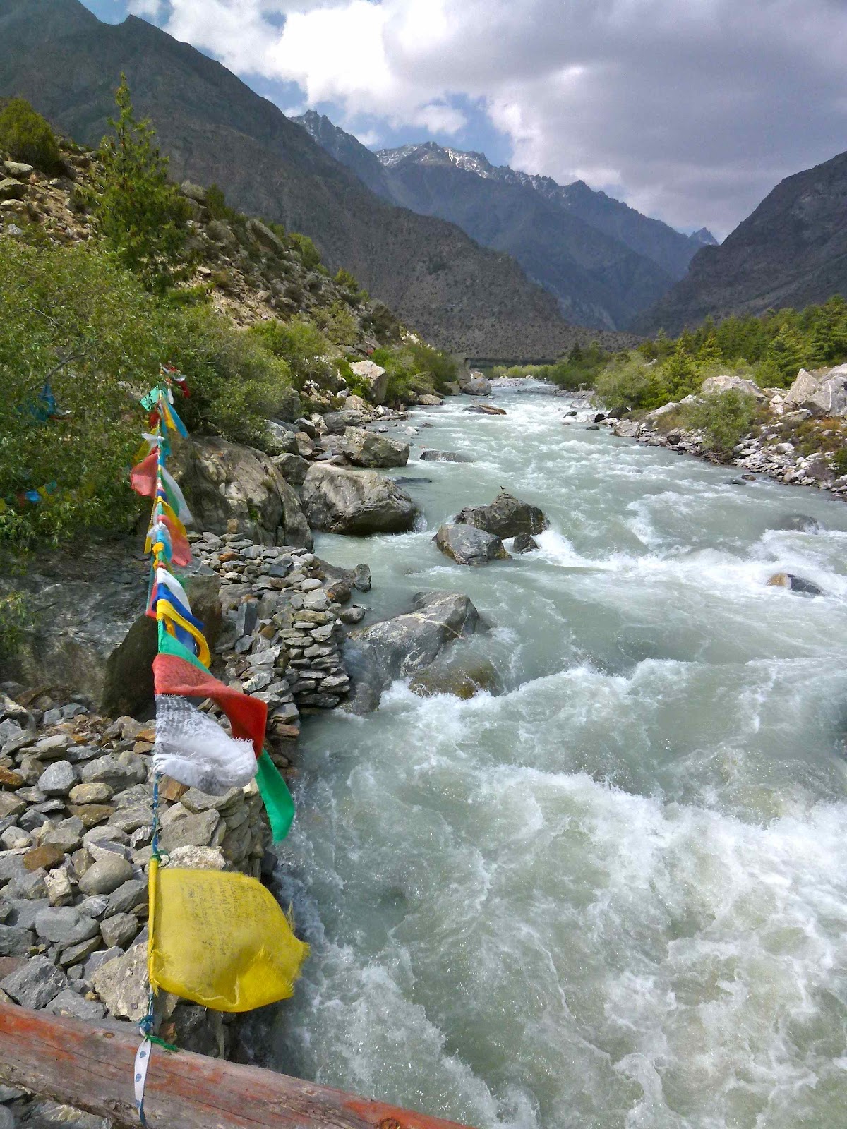
we headed north west we gained better views of the Karnali River deeply
entrenched in the valley 400m below us, the river mainly running in rapids
given the drop down from the Tibetan plateau. Attractive country, big mountains
behind us, deep valleys ahead, barley and buck wheat ripening on the terraces
below us. Jackals called us from a path on the opposite side of the valley and
a solitary vulture circled high above. Do they know something we don't?!
 |
| First camp at Dharapor |
After
four hours we reached a basic campsite at Dharapor 2360m. Fortunately, Lhasa
Beer was available, so a few happy smiling faces :-)
As
I write the boys are wasting loads of time trying to get a mobile phone signal.
Glad I don't have to be so connected!!
Saturday
9 June
As
I write this, it's just getting dark. The tent is on the edge of a precipice.
On a ridge opposite the campsite, there's a couple of monks banging drums,
chanting and blowing the occasional blast on a conch shell. God knows how they
got on to the top of the ridge.
It's
been a long day, starting well with a cheery breakfast, but off later than planned,
20 minutes after the scheduled start time.
This
was to be an omen for the day. Stop, start. Stop, start. Magnificent walking up
the Karnali valley, moving from areas where buckwheat and barley were ripening
but eventually reaching pine forests amidst vertiginous valleys. The team and
the crew are moving at different paces and will need robust management tomorrow
to bring them into harmony. My job. So I've been grumpy all day. The weather
held, despite a big build up of cloud this afternoon, and the light was
brilliant when we arrived in camp.
 |
| Karnali river valley |
 |
| Camp at Yalbang |
We're
now at 3000m, adjacent to a village called Yulwang (Yalbang), and we're about
halfway between Simikot and Hilsa on the Tibetan border. The walking has been
straightforward, typically Himalayan...'a little bit up, and a little bit
down'...they are masters of understatement here! We've climbed about 700m in
terms of net gain today, but that completely understates the amount of effort.
Steady climbs, steep descents, unstable paths in places...all part of the trekking
experience!
A
late dinner tonight, as the cooking crew took an eternity to get to camp. A
word in the ear of our head Sherpa later methinks...
Sunday
10 June
What
a night. Started raining within an hour of settling down. Then the monks
started. Banging drums, blowing conch shells...this was their outdoor retreat,
over a week, designed to draw out local demons and subjugate them with ritual
and prayer. But not in my backyard please! Then a small pack of jackals arrived
in camp, one announcing their arrival with the usual howl. They were quickly
dispatched by our crew, but at 3 o'clock in the morning, with monks still
active around us in various strategic positions it was not a night to sleep
solidly.
 |
| The offending monk! |
With
the trekking routine sorted out with our Sherpa we set off at about 0720 and
continued our steadily rising traverse along the banks of the Karnali river.
Shaded at first, but soon baking in the sun, we ascended and descended numerous
spurs, with the pine forest eventually thinning and stunted trees and juniper
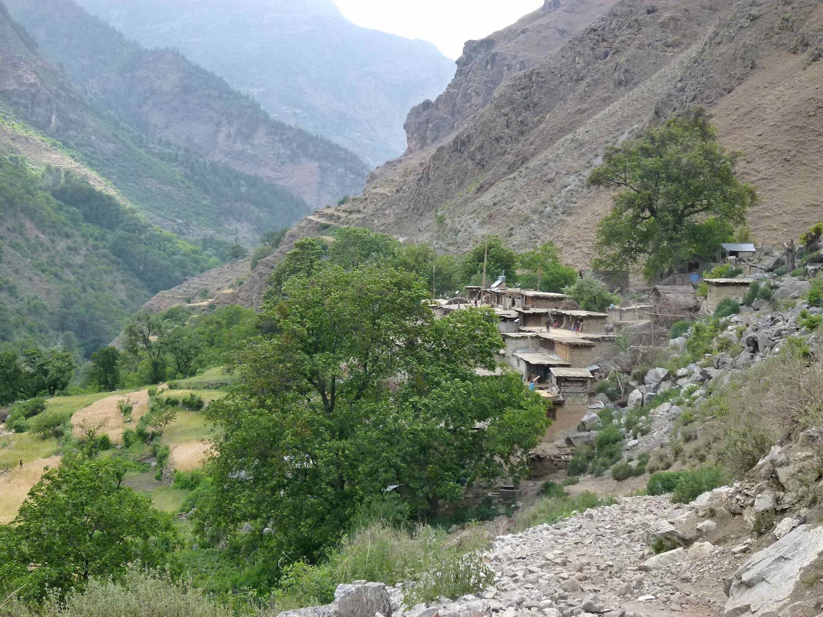
starting to appear as the valley widened around Muchu. Passing through another
checkpoint we eventually arrived in the small hamlet of Tumkot (Dhumbu) where
we had a leisurely packed lunch in a small teahouse.
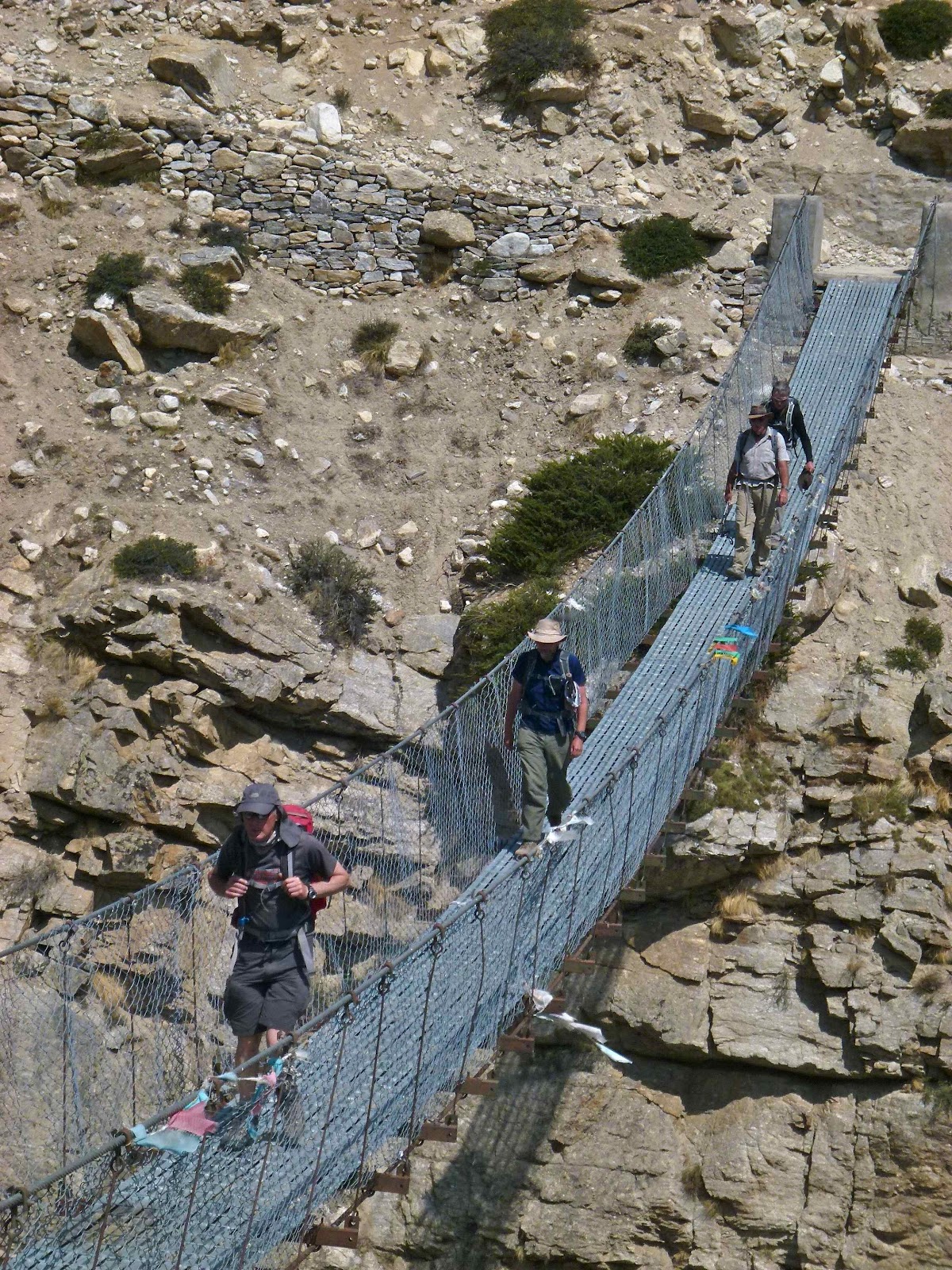
Then,
after crossing a suspension bridge, we started the big climb towards our next
stop, Pani Palbang, a trading post with access to China via a rudimentary road
to the border at Hilsa. The climb was about 400m, made more difficult by the
hot sun beating down upon us, and increasing fatigue in the group...the two
horses came in useful.
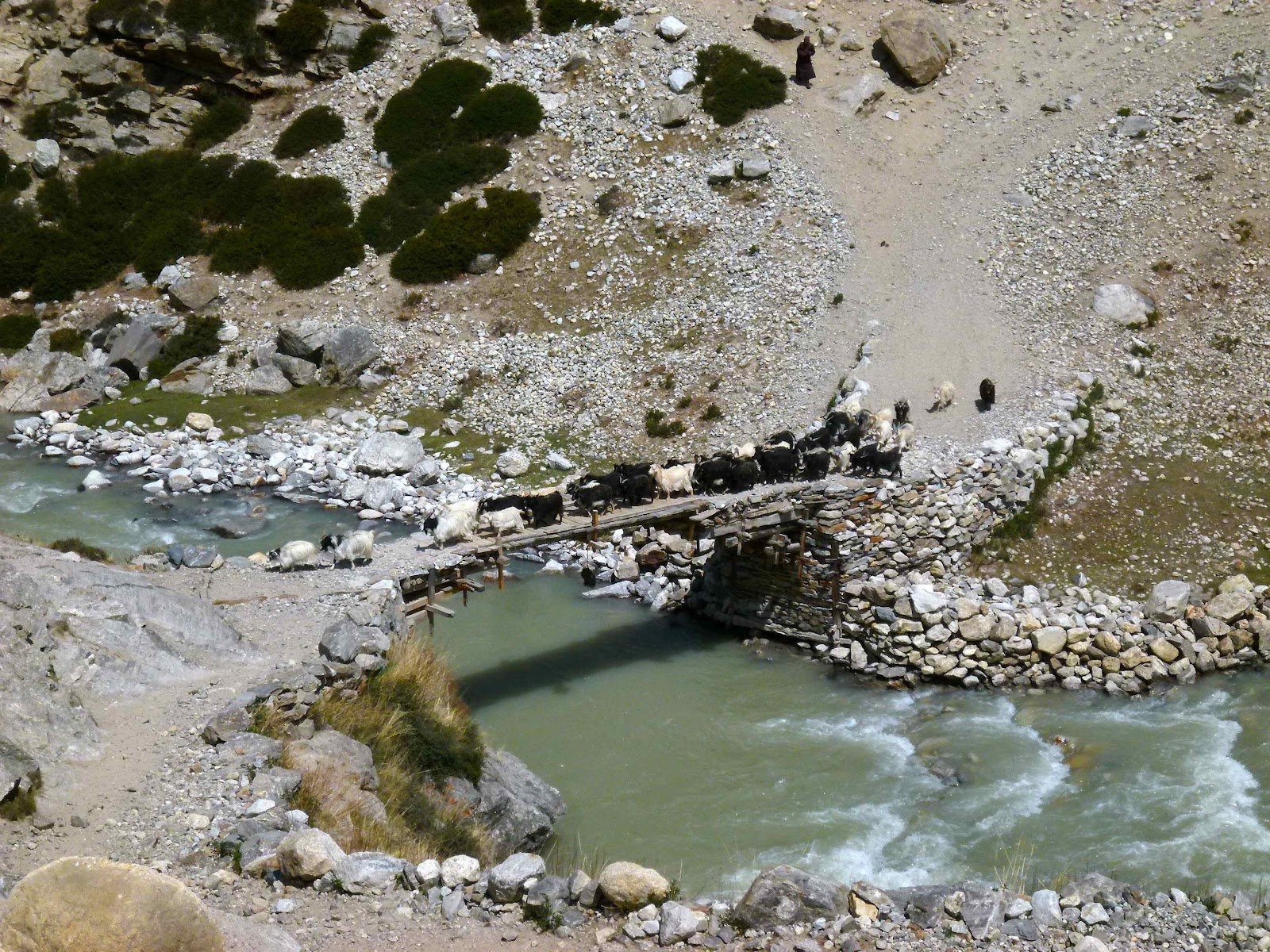
A
common sight on the trail has become herds of ronglu sheep with little
backpacks stuffed with goods from China, including white flour and
beer/alcohol. They used to carry rice or salt, but times move on!
Great
views back down the Karnali valley with some serious mountains appearing from
our lofty viewpoint, then a 'level' traversing path to Pani Palbang, made a bit
tricky in places where workman had started to prepare the rock for a future
road...some easy scrambling, but the big exposure got the adrenalin going for
all!
Finally,
after about 8 hours, we arrived in the sprawling camp site of Pani Palbang,
comprising trader's seasonal camp emplacements from which they hawked white
four, rice, noodles, beer and wine from China into the Humla valleys and
beyond. We found a rough spot in one of the bigger tents to relax and enjoy a
beer whilst the camp was assembled.
 |
| Pani Palbang |
A lot of tired folks in the team
tonight...we're now at about 3500m and it's been a sustained trekking day
today. Should sleep well tonight...no monks spotted, but I suppose there's
always the local jackals to disturb us! Still no means of contacting the
outside world. No mobile signal for days now, but the prospect of a landline in
Hilsa tomorrow...only eight hours hard graft away...
Monday
11 June
...and
it was hard work. The day started easily with a walk along a dirt road that has
now been built as far as Pani Palbang. Over the next three hours we gained
about 500m with the Yari Khola valley widening and new views to 7000m peaks
emerging to the west. Passing through the small hamlets of Yari, we eventually
reached a resting place at Shiv Shiv, and the full picture of the final
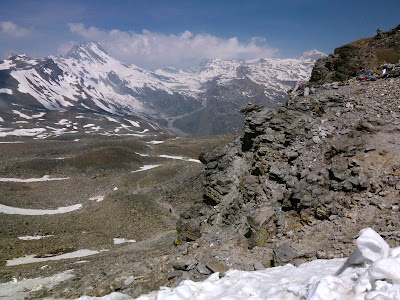
700-800m pull up to the pass of Nara La 4560m was laid before us.
 |
| Approach to the Nara La |
Easy at
first, but then the climb became a little more tricky with sloping paths on
loose ground. A little respite for most of us when we crossed on to the dirt
road, then a sustained 200m pull up steep loose ground brought us to the pass,
very windy at the top here, but great views back to our earlier route, and,
behold....the mountains of Tibet ahead of us, with the prominent holy peak of
Gurla Mandata revealing itself.
 |
| The team crossing the Nara La at 4560m |
We
could also see the start of the Limi Valley trek, a high level and seemingly
exposed path running high above the deeply cut valley, and the town of Sera,
the other side of the river, across the Tibetan border.
We
took a steep path down from the pass, but mainly followed the dirt road down as
the old trading route path looked steep, unstable and very exposed. Some
amazing views on the north side of the pass...some huge scree slopes, hundreds
of metres in height, huge ravines, and views all the way into Tibet.
 |
| Our first view into Tibet, the border following the peaks on the skyline |
 |
| Descending to Hilsa, and Tibet just across the valley |
 |
| Some beauty in this most barren of landscapes... |
 |
| Spot our path for tomorrow's walk! |
 |
| Rough road down to Hilsa |
 |
| The old trader's paths from the Nara La to Hilsa, very exposed! |
 |
| The Nepal/Tibet border at Hilsa |
We
finally reached Hilsa, 3647m, mid afternoon and the mules had yet to catch up
with us, so we had a couple of beers outside a basic teahouse, glaring at the
Chinese border post up on the hill opposite us in the afternoon sun, with a
dusty wind blasting us from time to time.
The
camp was on an open plain just above the village, so probably windy tonight,
but a spectacular setting nonetheless. This is just about as remote and cut-off
as I've ever been!
 |
| Hilsa |
Tuesday
12 June
A
big day for more reasons than you might imagine. I had made a phone call the
previous day, as there was a mobile telephone mast over the border in Tibet,
courtesy of China Telecom. From this I had heard that my son's partner, Ashley,
had gone into labour, so I was very keen to establish if I was a grandad yet!
So at 0300, I turned on 'roaming' and found pictures of newborn Olivia, 8 lbs 4
oz on WhatsApp. What a delight! A little texting with my son and daughter then
ensued, followed by a persistent village dog who moved from one end of the
village to another barking his head off. Ear plugs in, and, unusually, had to be
woken for the usual 0530 tea in tent.
 |
| Camp at Hilsa |
 |
| Start of our trek into the Limi valley |
 |
| The Karnali river at Hilsa, Tibet beyond the blue huts |
This
was also a big walking day, now heading east towards the Limi Khola valley, and
due to the position of the Chinese border, this required an incredibly steep
start once we'd crossed the Karnali River on a suspension bridge. I had been
concerned all night about the stability of the slope and the safety of the team
getting up it, but everyone coped admirably. The scree led us to an
unrelentingly steep path, which ultimately joined the trader's route coming in
from Tibet (which can only be used by locals - they are allowed to venture up
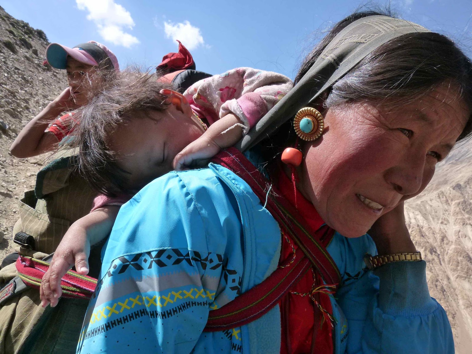
to 30km into Tibet by the Chinese authorities). Here we met a family group of
four from the village of Halji, further up the Limi Valley, with a one and a
half year old child strapped to his mother's back, having been all the way to
Taklakot in Tibet to receive treatment for pneumonia...what a life these folks
lead!
 |
| The very steep start up from Hilsa |
 |
| Hilsa receding far below |
 |
| Locals on the trail, having trekked from Taklakot in Tibet |
The
path became much more stable underfoot, and we made good progress, now
oscillating between 3900m and 4100m as
the day progressed, with precipitous drops to our right virtually all of the
way...again, not somewhere for anyone with vertigo...
 |
| Yesterday's descent route and Hilsa in the valley bottom |
 |
| Exposed walking high above the Karnali canyon |
It
got very hot during the day as we continued along the path, occasionally
crossing very steep ground as we passed numerous ravines and side valleys
entering into the Karnali, which for a period flowed through one of the
steepest canyons I've ever seen. Awesome, but needing a lot of concentration on
feet placement in some places.
 |
| An outstanding mountain path, as long as you don't suffer from vertigo! |
 |
| Villagers from Halji stop for a break |
 |
| The Karnali river far below |
It
became apparent that the previous source of water at our intended camp site had
dried up and it might be necessary to walk a further 2.5 hours to reach another
site, but we were, eventually, fortunate enough to find a small water supply
just ahead of the planned camp, situated on a pass at Chyang Lungma 4161m. Passing
through incredible rock scenery, we reached camp mid afternoon, and revelled in
enormous views, back south west to Humla Karnali Nadi and north east into the
Limi Valley, our objective for the next six days or so. We were also lucky
enough to spot an eagle midway along the path, and a herd of blue sheep
climbing the crags high above our campsite...they're very bold on steep ground!
 |
| The final section of a long day's walking...just up to the pass on the skyline: dig deep!! |
 |
| Camp at Chyang Lungma 4161m |
What
a day, with some splendidly exposed high level walking in bright sunshine and
news that my first grandchild had arrived safely. Happy days.
Wednesday
13 June
The
night was a difficult one on a sloping tent pitch, but I was not alone in the
team with this. A fine day dawned, albeit with a chilly wind at 4200m.
 |
| View west from the camp |
 |
| More exciting paths ahead! |
We
were off promptly at 0730, and headed on to the usual contouring path, again
with precipitous drops along much of its length with breathtaking views down to
the Karnali river far below. We passed a Buddhist meditation cave complex, Ya
Yip Phuk, (apparently used by the famed translator Lotsawa Rinchen Sangpo), which
locals told us had not been occupied for the last 110 years, but we could still
see mantras and murals painted on the cliff walls and the old kitchen and
sleeping quarters. We could also see various ritual objects in the rear of one
of the small chortens here.
 |
| Ya Yip Phuk, a meditation cave complex dating back over a thousand years |
Eventually,
the path seemed to fizzle out, but one had to look upwards to see where it was
heading, and 200m later, up a steep zig zag path, we reached a small pass,
Lamka Lagna at 4300m, offering a full view of the Limi valley ahead, surrounded
on both sides by castellated summits, and the junction with the Karnali far
below where it turned southwards into the valleys that take it down through
Simikot. A great spot.
 |
| The climb to Lamka Lagna at 4300m |
 |
| First view of the Limi valley, from Lamka Lagna at 4300m |
 |
| A good spot for a cup of lemon tea! |
 |
| Starting the descent into the Limi valley |
 |
| Snow leopard country |
Onwards.
A fine high level traverse continued above the Limi Valley and we eventually
turned into the valley containing the Syogang Khola and the village of Til,
with hillside monastery and retreat houses above. Beautiful views of the barley
fields on the many terraces, some being newly planted, and at the valley head
the snow capped peaks of the Nalakanka Himal and the summit snows of the mighty
Gurla Mandata, the former forming the border with Tibet at around 5000m+, and
the fine peak of Nala at 6422m standing proud.
 |
| The Limi river, on the approach to Til |
 |
| Entering the Syogang Khola valley, en route to Til |
 |
| The gompa at Til |
 |
| Til |
Lunch,
then an easy descent down through the terraces on to a good path which brought
us efficiently to the Limi Khola at Tiljung 3577m. Then a bonus...a small herd
of blue sheep, known locally as naur, grazing on the slopes above us, the male
keeping a beady eye on us as we passed. We're also now firmly in snow leopard country...we
are highly unlikely to see one, but it's an eery feeling that at some point one
will be watching you pass (our guide Kaji saw one near Manang, above the north
east section of the Annapurna Circuit, in 1999. It was eyeing up a walker out
in front but then spooked when the rest of the group appeared on the trail
behind him!).
 |
| A peek into Tibet...the snow dome in the centre is Gurla Mandata |
 |
| Descent to Tiljung |
 |
| Blue sheep ('naur') |
 |
| Tiljung |
The
final hour or so was an easy walk along the banks of the Limi Khola, on mainly
sandy soil, with breathtaking sandstone cliffs towering above us, one notable
for its huge calcite intrusions, one I named 'Devils Graffiti.' Two bridge
crossings and we finally reached camp just below the village of Halji 3741m, on
a windy bluff above the river. It's very windy and dusty as I write this.
 |
| Following the Limi Khola |
 |
| 'Devil's Graffiti'! |
 |
| Limi Khola below Halji |
 |
| Camp at Halji |
Thursday
14 June
A
disturbed night, sleeping with the sound of the Limi Khola beside the campsite,
rather like trying to sleep without ear plugs on a 737.
But
another beautiful day dawned, some clouds hugging the mountains on both sides
of the valley. Our first port of call was the nearby village of Halji, and on
our approach receiving the most friendly welcome from the villagers and, in
particular, the local kids on their way to school, all massing around digital
camera screens to see images of themselves.
 |
| View south from Halji |
 |
| Halji |
 |
| A warm welcome at Halji |
 |
| Mani wall on approach to Halji |
The
14th century monastery, Rincheling Gompa, in Halji is the second oldest in
Nepal, and we were lucky enough to witness the start of a puja to mark the
anniversary of the passing of the lama who had established the gompa over a
thousand years ago, Lotsawa Rinchen Sangpo (985-1055 CE), a noted translator of
Buddhist texts and accorded with the 'second wave' of Buddhist transmission in
Tibet. Rincheling Gompa is associated with the Dripung Kagyu sect of Tibetan
Buddhism, and is the main gompa of the Limi valley, restored with help from
Nepal Trust.
A
giant thangka featuring an image of Kyobpa Jigten Sumgön (1143-1217), the founder of the Drikung Kagyu sub-order was suspended over
the courtyard in front of the main temple hall, and the monks were chanting
away, interspersed with horns, cymbals and bells in the uniquely Tibetan
fashion. Local people, all dressed in traditional Tibetan clothes, randomly
appeared at the courtyard entrance, prostrated themselves in front of the large
thangka, and presented their offering to the presiding monk...sometimes a small
bowl of ground barley flour, others water, others butter. We were made very
welcome, and shown the main and peripheral temple halls as well as 'inner
sanctum' with multiple statutes of the Buddha with varying mudra positions. A
wonderful, atmospheric experience for all of us, and we each presented a kata
(a white silk scarf) in respect to the deceased Rinpoche. To cap it all, two
large griffin vultures soared high above the sun drenched cliffs to the west of
the gompa.
 |
| Rincheling Gompa, Halji |
 |
| Boy monks receiving butter tea |
 |
| Local woman prostrating in respect to the ancient lama, Lotsawa Rinchen Sangpo |
 |
| Locals making small offerings as part of the puja |
 |
| Halji |
A
great start to the day, and after a quick kora around this ancient walled town,
we ascended on to the main path towards Dzang (Jang), a path that occasionally
ran close to the fast flowing Limi Khola and then climbed steeply to cross
numerous interlocking spurs on the north bank. We covered a good distance in
increasing temperatures, with the sandstone cliffs soaring above us.
 |
| Terraces below Halji, sometimes subject to flash flooding |
 |
| Looking back along the path from Halji to Jang |
Eventually
we passed through another control post manned by three or four police officers
at Sunkarni. It was here that we established that only 60 trekkers passed
through the Limi Valley in 2011 and thus far, only 9 trekkers (this including
our group of six!) had passed this way this year. Nice to be part of such an
exclusive fraternity.
Onwards,
we soon reached the outskirts of Jang, had a quick lunch by the entrance gompa
in hot sunshine, before exploring the small town itself. At the fourteenth
century gompa, another puja was underway, this time with monks and the village
elders joined together in the ceremony. Old men in cowboy hats at the lower
level swivelling their prayer wheels and the women of the village on a balcony
above singing a hymn of homage to the deceased lama. Very atmospheric, although
we left early as it felt like a very private village affair.
 |
| Approaching Jang |
 |
| Jang |
 |
| Gompa at Jang |
 |
| Yak man |
 |
| Village elder displays traditional footwear! |
 |
| Jang |
Like
Halji, we are in a very Tibetan environment now. Traditional dress, jewellery
featuring blue stones for the women, Tibetan rather than Nepali language,
prayer flags strewn across every roof, and architecture identical to that seen
north of the border. And the standard greeting has changed to 'Tashi Dalek'
(pronounced 'Tashi delay') rather than 'Namaste'.
We
also managed to buy some beer to supply our camp. For the second night running,
we emptied the entire village stock of beer.
45
minutes on, we reached the camp site, another 100m or so above the village, at
4115m. On the way, I was out in front and coming towards me was a lone rider on
a horse heading for Jang. It was a young woman, face wrapped in a scarf against
the dust, and she was clearly asleep, letting the horse get her home on a well
trod trail. I clapped a hand to alert her to my presence and she startled and
moved the horse into a trot, as if in embarrassment.
 |
| Departing Jang for the camp |
 |
| Camp next to Limi Khola above Jang |
We
are now in a wider valley area where the river has taken the opportunity to
spread into several channels. Fortuitously we are also close to a hot spring,
not sulphurous at all, so after a beer chilled in one of the river channels, a
good wash was enjoyed at the spring outlet itself, and a shower tent erected
for everyone to give themselves the first good clean in days. The only negative
at this location was the constant demand for money from various locals,
including, apparently, a bunch of road construction workers who arrived looking
for a 'donation'...they were politely but firmly seen off by our affable guide.
A
splendid day of local culture and easy walking. And, no dust storms
tonight...what a bonus.
Friday
15 June
A
difficult night, disturbed by coughing caused by all the dust ingested over the
past week or so, and, because of the altitude some evidence of Cheyne-Stokes
breathing, where the body isn't taking enough air per breath, and then suddenly
has to catch up with a deeper breath to compensate. Three or four of us
reported this in the morning.
We
set off in a cool wind at 0730, more cloud about today than we've seen in some
time.
Heading
east then north east, the path meandered across river meadows, crossed a few
low bluffs and eventually became a rough road as we approached some ruined
buildings at Traktse. We had earlier passed semi-nomadic people with tents made
from woven horse tail hair, tending dzo, yaks and cows. We had also observed a
number of folk using ponies to help them plough small terraced enclosures for
the next planting of barley, potatoes, or mustard. This is very primitive
farming.
 |
| Ploughing with the aid of a pony |
 |
| Semi-nomadic herders, seen en route to Tholing |
 |
| Limi Khola at Tholing |
Several
high snow capped peaks emerged behind us, the most notable being Chimma Chuli
4958m and it's neighbour Hilsa Tuppa 5409m, plus a fine peak, unnamed on the
map at 6034m, with a needle like rock pinnacle for the summit.
There's
a trading post at Tholing 4152m, but the two shops there were devoid of any
stock. They are supplied via a rough road which enters from Tibet across the
Lapche La, about 25km to the north, and we later found out that this road is
currently blocked by a landslide, hence the shortage of supplies. No beer
tonight!
 |
| View from Traktse |
South
of Traktse, we crossed a suspension bridge over the Takche Chu, below the
abandoned buildings of a village once known as Gumma Yok (4170m), and
approached a large terminal moraine faced with really fine white sand, most
unusual...it appears to be sand that blows into a dune in the lee of the
moraine, as there are large sand and gravel flats directly above, formed by the
moving waters of various large glacial outflows.
Climbing
up through the sand was tiresome, and at the top we were hit by a strong wind
blasting down from the 5000m pass of Nyalu La, which we cross tomorrow. We
crossed the river plain, using the horses to cross several deep water channels
and stopped for lunch near an attractive lake, the 1200m long Tshom Tso,
beautifully coloured by glacial sediment.
 |
| Crossing the Takche Chu |
 |
| Climbing sand dunes...hard work! |
 |
| The windy approach to Tshom Tso |
 |
| River crossings below Tshom Tso |
The
next couple of hours were spent ploughing up the east side of the lake into the
valley containing the Talun Khola and other glacial rivers which empty into it.
This is hard, bleak country, with huge mountains towering around us on all
sides and the Nyalu La getting ever closer, revealing tomorrow's ascent route
as we progressed up the valley. Some pink geese and black and white cranes
spotted, as well as a few large but nervous marmots.
A
good journey, 7 hours in all, with our final camp, Talun (Limi) Camp at 4380m.
 |
| Tshom Tso |
 |
| Talun (Limi) Camp, 4380m |
Saturday
16 June
Most
of the team had a good night's sleep, so were very ready for our big day over
the final big pass of the trip. We walked from Talun Camp 4380m to Nyalu La
5001m, the fastest team in 2 hours 45 minutes and the final group 3 hours 20
minutes...all well under the time suggested by our guide. Well done the team!
The
route was an easy slog up a newly made but rough road, gaining a couple of
hundred metres in height in the process. The trail then steepened considerably,
and the shortcomings in the local road construction process was all too
apparent, with new streams choosing the road as their preferred channel and the
road already collapsing in places. The ground was steep and unstable, with a
little hard packed snow to cross, but it enabled rapid height gain into a big
basin immediately below the pass itself, with splendid views unfolding behind
us as we crossed the rocky ground to make the final ascent.
The
final pull was short and steep, but just safe enough for horses and our mule
train. At the top, a shade over 5000m, the views were stupendous. It was hazy
in the distance so the potential view of Kailas was not seen today, although
Gurla Mandata's snow slopes could be viewed from our vantage point.
 |
| Climbing to the Nyalu La |
 |
| Summit of Nyalu La, 5001m |
 |
| Views north from the Nyalu La |
 |
| Our sherpa, Kaji (second left), with members of our support team |
 |
| The full team at Nyalu La |
 |
| 'Proof'! |
We
enjoyed views west to Phupharka Himal, north east to Changwathang (6130m) and
the partially clouded massif of the Changgla Himal to the east, the highest
point 6246m.
There
was an easy descent for lunch above Selana Daho lake, then down via a new
roughly hewn road into the upper reaches of the Chhungsa Khola with towering
cliffs 400-500m high above us on either side with some very high waterfalls.
The only real hazard today was stone fall from a large excavator driving slowly
above us to dig out more of the road!
 |
| The long descent into the valley of Chhungsa Khola |
 |
| Huge waterfalls above our penultimate camp |
It
was a long descent down the Chhungsa Khola to our camp at 3907m, giving a total
descent of over 1100m today. Our camp is next to the river on yak pasture, so
careful where you put your feet!
And
it's much hotter down here too.
Sunday
17 June
A
disturbed night on an undulating tent pitch.
Last
evening our team had decided to elect for the 'high route' back to Simikot, a
remote two day trek over some higher passes, avoiding some duplication of our
first couple of days in Humla and the heat lower down in the valley.
Little
did we know what we'd let ourselves in for, especially now that some team
members are nearing physical exhaustion and the camp food quality has
diminished as the crew were unable to replenish supplies in the Limi Valley due
to a landslide blocking the access road from China.
The
day started innocuously enough, dropping down the Chhungsa Khola valley about
100-150m, then turning east into the valley of the Takchi Khola, walking up
through pleasant woodland, mainly pine, silver beech and rhodedendra bushes. We
happened on quite a few road workers who are manually cutting a road out of
this valley over to Kermi.
Rising
above the wooded area, the valley widened out with a more bleak high mountain
feel, with yaks and dzo grazing high pastures above us.
 |
| Takchi Khola |
The
pass, southwards from our track, eventually came into view and a river crossing
on a frail wooden bridge brought us to a climb of some 250-300m, mostly easy
going, crossing some old snow but with a horrible final pull up the last 70m or
so on very loose mud and shale. Unpleasant and hard work, but emerging through
a gap cut in a low snow cornice, we were again rewarded with exceptional views
from the summit of Sechi La 4530m. Mountains like Changwathang 6130m close to
the Chinese border reared up again, and hazy views to the Saipal Himal in the
south.
 |
| Sechi La 4530m |
We
didn't linger long, as there was a substantial descent to do before lunch, and
700 hard metres later, much of it on loose dusty sand and grit, we emerged in
the valley of the Thangui Khola, and sat close to the fast running river in hot
sunshine, with some locals making the local beer, chang, in a hut near the
river. Locals are less friendly around here. They often don't respond to
'Namaste' but come and sit close to the team to just observe modern trekkers
with all their gear and gadgetry. More often than not, they attempt to scrounge
medication for various ills, and occasionally we've been able to help out.
We're amongst the Humla people again, women usually adorned with nose
piercings.
 |
| The sustained descent from Sechi La |
After
lunch we had a steep climb of about 250m to attain our second pass of the day,
at about 3880m, then a wonderful high level 'balcon' path brought us to the
final pass of the day, the delightfully situated Chhubang Lagna at about 3900m.
There were views back to the Sechi La...it seems a long way back now, and is
600m above us, and views over the mountains to the south, snow covered but
largely lost in the afternoon haze.
 |
| Looking back to Sechi La, the notch on the horizon! |
 |
| The third and final pass of the day, accessed along an easy 'balcon' path |
A
quick break, then a final easy descent to a nicely situated camp, Lek Dinga at
3714m, next to a small lake.
It
had been a harder day than we all had expected, but our final trek day tomorrow
will soon dissipate our collective weariness. Roll on a decent bed and a cold
beer!
 |
| The final camp at Lek Dinga, 3714m |
Monday
18 June
Final
day. Awoke to spots of rain on the tent, the first precipitation for weeks!
Low
cloud, rolling down into our little valley retreat, adding a lot of atmosphere
and a complete change in environment.
Everyone
was keen to get going and we made quick progress down through barley fields
being prepared for the next crop, with mist circling around us. An easy descent
at first, passing through the deserted village of Lek Hepka and then more
steeply down to Yakba (lower Hepka), a total descent of some 700-800m in under
two hours. A quick stop by the Hepka Khola, before the final (or at least we
thought) climb of about 250m up and across the many interlocking spurs between
us and the final objective, the air strip at Simikot.
 |
| Clouds down at Lek Dinga |
 |
| Lek Hepka |
 |
| Hepka Khola |
It
was a good pull up a well defined path, and we took a break at some huts after
about an hour of ascent, only to find the path continuing to rise. And this it
did, until we found ourselves at almost 3300m again, having steadily climbed up
another contouring path around the many spurs high above our first trek night
stop at Dharapor, which was now almost 1000m below us.
However,
in normal fashion, the presence of prayer flags at the very top of the trail
indicated that we were now started on the descent route to Simikot, the first
view being of the military camp on top of a prominent hill above the town.
 |
| Rejoining the Karnali river valley, high above Dharapor |
 |
| Simikot in sight...never thought we'd get there!! |
We
finally reached Simikot at about 1500, with tired gait but huge relief on our
faces...a big trek safely completed by all.
A
few cold Tuborgs and a good dinner settled us in for our night in the Nepal
Trust Guesthouse, very basic but better than a tent! But we're now back in a
town, and the night had the usual cacophony of barking dogs, hee-hawing donkeys
and the army bugler at 0500. Ho hum...
 |
| Tired feet and bodies, and waiting for a cold beer to arrive! |
 |
| Saying thanks to our trekking team |
Tuesday
19 June
Up
early, good weather up here at Simikot, and expectant of an early flight back
down to Nepalgunj and onwards to Kathmandu.
 |
| Waiting for the flight...but the plane didn't arrive due to bad weather |
However,
four hours later we were dragging our luggage back up to the Nepal Trust
Guesthouse. No flights today. There's bad weather in the valleys to the south
of us, and clear visibility is essential for the fixed wing aircraft that ply
their trade on this route.
So,
a lazy day, reviewing photos taken over the recent trek, checking out the town,
and generally wondering whether we'll get out of Simikot tomorrow.
Simikot
is quite big once you start exploring it. The women here are usually adorned
with nose rings, sometimes combined with other nose piercings, and huge gold
earrings are the vogue. The men often wear the normal Nepali 'fez' type hat,
and a few were observed drunk as we walked in search of treats like Coke and,
for me, salty crisps! There's a lot of liquor stores in the town, so rather
like Sikkim, I guess that alcoholism is an issue up here.
We
increased our chances of getting back to Kathmandu by provisionally booking a
helicopter to get the six of us down to Neplagunj in the event that fixed wing
don't fly tomorrow either. A bargain at $4000 between us :-(
 |
| This might be our transport tomorrow... |
Wednesday
20 June
Another
disturbed night with dogs barking most of the time. And a big change in the
weather today. Low cloud and persistent light rain. Well, at least we don't
have to trek in it! Whether we get out of Simikot today remains uncertain as I
write this at 0550!
Update
1330: we're now in Nepalgunj. The skies miraculously cleared and we were able
to cancel the helicopter and save ourselves loads of dosh!
Simikot
airport suddenly became the busiest airport in the world when the skies
cleared. Wealthy Indians who had been flown down from Hilsa on the Tibetan
border by helicopter having done their once in a lifetime pilgrimage to Kailas
(the Chinese seem very happy to accommodate Indian nationals...shame about the
rest of us....grrhh...) loaded themselves on to single engine light aircraft
(rather them than me!), assorted Nepali traders loaded themselves and bags of
unknown commodities on to ageing Sita planes, and then, much to the glee of our
team, the Tara Air Twin Otter appeared in the sky, and we were swiftly away
over stunning landscapes southwards to the arid Nepali/Indian border, a flight
of about forty minutes.
 |
| The weather improves, and six happy lads get their flight to Nepalgunj |
Neplagunj
is HOT...so this blog is being written in the air conditioned bar of the Hotel
Sneha, still under refurbishment but with friendly service, good food, chilled
Nepal Ice :-) and adequate air con. We'll transfer later today and hopefully be
in Kathmandu before nightfall.
Thursday
21 June
Three
of the team got away to Kathmandu last night, leaving the other half of the
lads overnighting in the Hotel Sneha again. Good food, a couple of beers were
great but a long hot night had to be endured with very noisy air con and
ceiling fan.
Another
two lads got away on a stand-by basis on Yeti Air at 0930, so guess what? Yep,
yours truly is back at the bloody hotel again, Billy No Mates, waiting for the
1545 flight later. Hope nothing screws that up!
Well,
fortunately it didn't! The end of expedition dinner at the Third Eye in Thamel
beckons :-)
HUMLA - Summary
The
Humla Circuit looks easy on a map. Especially when the scale is 1:150,000.
But
it's not to be undertaken lightly.
Just
getting to the start point requires two small aircraft to get you there. The
sense of isolation is immediate.
At
Simikot you are four days walk from the nearest road head. The airport is famed
for its closure due to bad weather in the valley systems to the south. The
folks in Simikot drink a lot and the ladies of the town are uniquely adorned
with nose rings and heavy gold earrings.
Then
the trekking starts. Into the mighty chasm of the Karnali River valley. For
three days of huge ascents and descents as you wind your way around the many
spurs and adjoining valleys. Then the pass before you sight Tibet for the first
time. A lot of effort, up and then, down, down and down some more. The
landscape becomes harsher. No more the verdant terraces of barley and mustard,
no more cooling pine forests. Harsh, barren rockscapes, and the
Tibetan border, temptingly visible across a small suspension bridge.
Never
before had the sense of isolation been felt more keenly. Until...
...the
start of the Limi Valley section of the trek. The position of the Tibetan
border precludes an easy start. It's up a long section of steep unstable scree.
It screams 'if you want access, you'll have to work for it'. But once on the
trail eastwards you're on a high level traverse, not a place for folks with
vertigo, with awesome scale all around you. Two days of this and you've earned
your spurs. Suddenly villages start to appear. People make a real effort to
meet up with you. Gone is Nepali, here is the Tibet that the Chinese are trying
to subjugate just over the border. Traditional fur, yak wool and goatskin garb,
gompas and meditation caves dating back over 1,000 years, fields ploughed with
wooden tools harnessed to ponies, and the resonance of mantra and chant in
recognition of great lamas of the past.
Then
the real work begins. High pass after high pass. Huge descents. River crossings
on our two resilient ponies. Face scarves drawn up against the wind and the
dust.
Then,
finally, after you think you've done all the work, another 'little bit up' in
Nepali parlance. And then Simikot, a flight delay of twenty four hours, and the
triumphal return to civilisation. What an experience. Unforgettable. Almost
unique, especially when we were told that only three foreigners had passed
through the Limi Valley before us this year.
So,
over to you...take your choice. But like so many other places in the precious
environs of the Himalaya, go soon. As I speak workers are creating new roads
into the region, many hand hewn, so progress will be slow, but like all things
in our modern world, it's relentless, and new trading routes, mainly into
Tibet, are opening up and releasing modernity into this sublimely unspoilt
region.
We
have been a lucky bunch of guys to have witnessed the last vestiges of the old
world.
Simple, sustainable, surreal.


1 comment:
Wow, you had me hanging on every word. The photos are amazing! This made me wish I was a part of the adventure. I collect Himalayan singing bowls and also use them for sound healing. That’s about as close as I will ever get to the area. Thank you for an incredible journey
without the pain of it all or the dizzying heights.
Namaste and Buddha’s blessings
John H. Watson
Post a Comment